Posts

Madagascar: Final Blog

Image
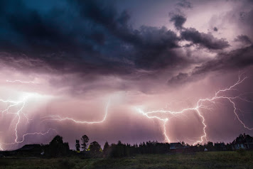
 Madagascar: Final Blog      Madagascar is located in the Indian Ocean off the coast of southern Africa and is the fifth largest island. The population of the island is considerably about twenty-eight million and currently has one of the planet’s highest poverty rates. Despite the poverty rates and population growth, the island is considerably beautiful with its people and environment. Also, the constant hazardous weather is prominent and treacherous.      Madagascar has numerous natural hazards that are considerably dangerous. One of them is cyclones. Cyclones are an area of low atmospheric pressure with rotating winds. The intensity depends on their sustained wind speeds and lowest atmospheric pressure. A form of this would be a tropical cyclone. Tropical cyclones form over warm tropical waters between the latitudes of 5-20 degrees. Extratropical cyclones form over land or water in temperate regions between the latitudes of 30-70 degrees. Both of the...

Madagascar: Coastal Hazards

Image
Madagascar: Coastal Hazards Madagascar does experience coastal hazards. It is not a secret why so many people want to live in the coastal regions. There is beauty in it, but also great precautions. Although, coastal hazards are prone to many natural hazards such as erosion, big storms, flooding, tsunamis, and sea level rise. Madagascar experiences all of these hazards on their small continent. One of the critical reasons Madagascar experiences coastal issues is due to sea level rising. Sea level rising occurs with the effects of global warming. This happens when water from melting ice sheets and glaciers with the expansion of seawater. Shoreline erosion generated by sea level rise is a substantial issue to the coastal ports and beaches of Madagascar. In Madagascar, the yearlong rise is about 3 mm per year. “Regional variations exist due to natural variability in regional winds and ocean currents, which can occur over periods of days to months or even decades.”  Rising sea levels co...

Madagascar: Severe Weather

Image
  Madagascar: Severe Weather Madagascar does experience numerous amounts of severe weather. Thunderstorms are very common during the rainy season in the central highlands. Lightning is considered a critical hazard. The capital of Madagascar, Antananarivo, obtains an average of 1.4 meters of rainfall between the months of November and April. That is a total of five whole months. The bare season is enjoyable and sunlit, although it can be cool in the mornings. Madagascar has experienced five storms in two months. Between the months of January and March, more than 200 hundred lives were lost. Families lost their homes, food, drinking water, basic necessities following each storm. There is another issue that an individual wouldn’t consider as severe. The north and eastern regions of the country have conquered flooding and heavy rains. The south has been encountering the worst drought in forty years. Roughly 1.5 million people in the domain are now dangerously food insecure. The communi...

Sabrina's Blog 8: Madagascar Mass Wasting

Image
 Madagascar: Mass Wasting Madagascar experiences landslides more than anyone realizes. The recent major occurrence was January 2022. At least thirty-four people died and over 35,000 people have been forced to take shelter in displacement sites established by authorities. 6,800 homes were under water and many others were at risk of flooding or fall apart. Citizens of Madagascar were facing severe hunger during this time. Madagascar, as of right now, has a high hazardous level of landslides. The eastern part of the country will be the most effective rather than the western side. Although, cutting through the center of the island, the hazardous level of landslides is at a medium level, but still considered a risk. Citizens that live in the lower eastern part of the country move quickly away from its path. Stay clear of trees, power lines, and poles. The slope can expect failures for hours to days afterwards. If you are indoors during a landslide, find cover in a section of the buildin...

Sabrina's Blog 5: Madagascar Volcanoes

Image
  Madagascar: Volcanoes Volcanoes happen constantly when there is a divergent plate boundary. Divergent plate boundaries are plates that pull away from each other. Most divergent plates are discovered along mid-ocean oceanic ridges. These plate boundaries cause the hot mantle rock to emerge since the plates are moving apart. Divergent plate boundaries cause volcanic activity and small earthquakes. Madagascar has a divergent plate, so volcanic activity can occur on the island. Madagascar has a medium level of volcanic activity. The activity is mostly centered in the middle of the island. If a volcano were to occur sooner than expected, people should move south of the island. The volcano is a bit north of the island. The volcanic lava can cause damage to multiple buildings leading to casualties. Also, ashes from the lava and maybe fire can cause a public health hazard. The ash can cause sensitivity to the eyes and airways. Madagascar can do some numerous preparations for volcanic act...

Sabrina's Blog 3: Madagascar Earthquakes

Image
  Madagascar Earthquakes Madagascar is exposed to many hazards such as cyclones, floods, and sometimes earthquakes. Madagascar has an early warning system for natural hazards. An early warning system is an instrument used as a monitoring system, forecasting, and predicting disasters that may occur and can be at risk to human life. This assists with the prevention of losing human life. There is also a 9-3-0 Hotline located specifically in Madagascar. Madagascar has a low level of earthquakes. It isn’t too constant or too hazardous compared to the other events that happen. On the other hand, Madagascar has a high hazard level of landslides as well as cyclones. The constant rainfall, earthquakes, and other possible hazards make the landslides a periodic hazard. Madagascar is only about a thousand miles long and two-hundred fifty miles wide. This island is bigger than California. The recurrence of cyclones makes the entire continent an extremely high level of being hazardous.   Re...

Sabrina's Blog 2: Madagascar Plate Tectonics

Image
  Madagascar Plate Tectonics Madagascar is within the African Plate since the country is very close to Africa. The country is next to the Australian Plate. Madagascar is outside of the Ring of Fire. Within the country, there are active volcanoes from the last million years. Madagascar is close to the Southwest Indian Ocean. There is also a common earthquake activity. Madagascar has a convergent plate, and the map declares there is an overriding plate.  The African plate consists of both an oceanic plate and continental crust. The country is within the Atlantic Ocean and close to the continent of Africa. The plate boundary has both convergent and divergent boundaries. A convergent boundary that refers to two continent tectonic plates colliding. The oceanic crust with subduct underneath the lighter continental crust. If one side becomes stuck in any way, there will be more than enough pressure to cause an earthquake. If the material goes further, the heat would cause it to melt ...